"Day Hiker’s Guide to all the Trails
in the Smoky
Mountains"
Hiking in the Great Smoky
Mountains National Park
|
21,830 copies sold – 2nd
printing of 4th edition now available - About the Authors Note that
there is now a daily $5 parking fee for the Park. $15/week and $40 season
parking passes are also available. 2025 Trail closings – Scott Mt Trail remains closed;
Bullhead closed M-Th from May 5 – Nov 6; open
weekends to hikers. Flint Gap fire contained, but Hannah Mt,trail from Parson Branch Rd
to Rabbit Creek trail is
closed. Energy
Mile Theory and NRG Equivalent Calculations Book Reviews |
By Elizabeth L. Etnier Graphics
by Michael Etnier Want to hike all the trails
in the Smoky Mountains? The Smoky Mountains
National Park contains 522,000 acres of forested land that traverses the Blue
Ridge mountains between Tennessee and North Carolina and may be accessed from
either state. There are approximately 800 miles of trails in the Great Smoky
Mountains (GRSM) that are officially maintained by the Park Service and may
be used for horseback riding or hiking. I have hiked all 800 miles of trails in the Smokies, and have written the Day Hiker’s Guide to all the
Trails in the Smoky Mountains to
assist others who aspire to hike all the trails in the GRSM. Currently, there are 157 maintained trails
in the Smokies and I have laid them out in 75 easy
to follow day hikes ranging from just a few miles to over 20 miles in length.
I provide you with an approach to hiking all of these trails that minimizes
duplication of miles hiked while ensuring that no trail segments, or spurs,
are left behind. Indeed, if you follow my approach, you can hike all the maintained
trails in the Smokies in a total of only 1090
miles! Although intended for the experienced hiker, this guide is helpful for
the hiker who wants to go to a particular section of the Smokies
and plan out a shorter hike that suits his level of endurance. Additionally,
there is a section listing 26 family-oriented hikes. Click on link
to see a list of major revisions that have been added to the earlier 4th
Edition (2015), and updated 4th Edition (Publication date August,
2020). This guide
has color-coded maps showing the hikes for each area and tables that list the
trail sequence and total mileages for each hike. Included are a list of
available car or boat shuttle services for the more remote hikes, a handy
checklist of all trails, and over 30 color photographs of the Smoky
Mountains, wildflowers, and historic structures in the Park. To download a
working Excel file that will total your miles hiked as you complete and input
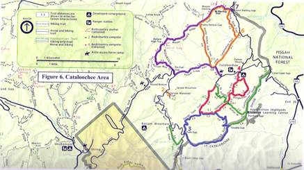
them, click on this link. Map and
example of corresponding table for Cataloochee Area
Paperback,
Updated Fourth Edition, 6 x 9, Spiral-bound, 132 pages ISBN
9780980-0742-77, $22.95 plus tax (where applicable) and S&H I will be out of the country from June 24 – August 10,
2025, and will be unable to process orders during this time. If you want a book,
you can pick one up at any of the Smokies Visitors
Centers, or local outfitters. 2nd
Update of 4th edition now available |